Friday, October 8, 2010

Hoover Dam

Took a detour on the long drive back to Los Angeles to visit Hoover Dam, which dammed the Colorado River at Black Canyon to create Lake Mead.


Overview of Hoover Dam complex from Arizona side

View of Hoover Dam from Arizona side

 Hoover Dam and new road bridge over Black Canyon

View of Lake Mead from Nevada side

Finally made it back to California


for the drive into the maze of freeways in Los Angeles to drop off the car and walk to Hilton Hotel, fortuitously only 400m down the road from the car rental return location.

So the trip was:
  • 7 days
  • 2600 miles, of which I drove 2296 miles = 3695 km
  • 6 states (OK, 5 really...if you don't count Colorado - see posting for Monument Valley on 5 October)
  • 4 new states (Nevada, Utah, Arizona, New Mexico) making 29 for lifetime list
  • 3 National Parks, 1 National Monument, 1 National Preserve and 1 Tribal Park
  • 14 state border crossings
  • some amazing weather and a lot of red rock!
but plenty saved for another time.

Highlights? Where do I start? The Grand Canyon is certainly awe inspiring, Bryce Canyon is astonishing and Zion Canyon beautiful - that's why they are National Parks - but for the best overall experience, the wide open grandeur combined with the ability to get close to the landscape and the Navajo people made Monument Valley my favourite.

      Thursday, October 7, 2010

      Grand Canyon - Colorado River

      The car was left in the hotel car park today as the whole day was spent on an organised tour (including hotel pickup) to the Grand Canyon Cavern and jeep drive down the Peach Spring Canyon to the Colorado River at the bottom of the Grand Canyon.

      First stop was Seligman, on the original Route 66. When the I-40 Interstate Highway was built in the 1970s, the locals feared the town would disappear with no through traffic. Two brothers, who owned businesses in the main street, petitioned the government to designate Route 66 an historic road making it a tourist attraction. The petition was successful and the town is thriving with many quirky shops such as the one below, apparently still owned by one of the brothers who saved the town.


      Seligman was the inspiration for the town Radiator Springs in the Disney-Pixar movie Cars.


      Next stop was the Grand Canyon Cavern. This is a significant distance from the Grand Canyon (2 hours drive from the Grand Canyon Village) and has a colourful history as a privately owned tourist site. Unfortunately, the cave is disappointing. It's a dry cave, as the guided tour commentary repeatedly points out - less than 6% humidity means no bacteria or mould can survive - but this also means there are very few cave formations commonly found in wet caves. The commentary makes a big deal of cave conservation and how the poor tourism practices of the past have damaged fragile formations but the latest tourist attraction at the cave is a fully functional "hotel room" that can be booked for a night in the cave. The hotel room is built with walls about a metre high and no ceiling so the guests have the feel of sleeping in the huge Cathedral Cave - cute idea but a giant eyesore for the rest of the cave visitors. There are two points of interest in the cave. The first is the stockpile of emergency provisions stored here during the 1962 Cuba missile crisis. Apparently a number of caves across the country were designated as nuclear fallout shelters with sufficient water, food and medical supplies for 2000 people for 2 weeks - and it's still there! The second is the evidence of a skeleton of a Giant Ground Sloth that fell into the cave about 14,000 years ago and the scratchings on the wall above the skeleton are hypothesised to be from the animal trying to climb out.


      The highlight of the tour though was the drive down to the Canyon in open jeeps. The road runs through the Hualapai Indian Reservation from the town of Pearl Springs, down Pearl Springs Canyon and Diamond Creek to the Colorado River at the bottom of the Grand Canyon. A permit is required to drive this road.

      Pearl Springs Canyon

      The river was a deep reddy-brown colour from the rain run off from the last few days.

       Colorado River, upstream

       Colorado River, downstream

      Rock formation known by the locals as "Snoring Indian" 

      Being late in the afternoon, the drive back up Pearl Springs Canyon showed the canyon in a very different light from the down trip.


      Tomorrow, back to LA via Hoover Dam.

      Wednesday, October 6, 2010

      Grand Canyon - South Rim

      As noted in the previous post, I got to the Grand Canyon NP late afternoon and fortunately, the weather cooperated with some spectacular lighting of the canyon.


      and after "donating" another $25 to the NPS, I drove to each of the main viewing points on the South Rim. For this post I'll just let the images tell the story.

      Desert View


      Lipan Point


      Moran Point


      Grandview


      Mather Point


      291 miles driven and what a finish to the day :-)
      Tomorrow a jeep trip into the canyon.

      Canyon de Chelly

      A pleasant change this morning with a 2 minute drive rather than 2 hours (or more) to today's first encounter with the red rocks of Arizona and an added bonus was the blue sky!


      Tourist access to Canyon de Chelly is via two drives along the North and South Rims with a variety of overlooks of the canyon. As noted yesterday, I visited the first two North Rim sites last night on the drive into Chinle. I've moved them here.

      Yellow dots indicate locations of ruins in close-up photographs.

      Overlooks on the North Rim

      Massacre Cave
      This site is more famous (and named) for a 19th century massacre of Navajo but there are Anasazi ruins high on one cliff:

      Massacre Cave ruins

      Mummy Cave

       Mummy Cave Overlook

      Close-up of Mummy Cave ruins

      Antelope House
      On the walk from the car park to the canyon viewing sites, there were several trees that were natural bonsais. This juniper was less than 50 cm tall.


      The angle of the early morning sun made it difficult to photograph the canyon (this photograph required some significant work in Photoshop Lightroom to get it to look like what the eye sees naturally) but it is a spectacular spot:


      There is one ruin site at this location


       Close-up of ruins at Antelope House

      Overlooks on the South Rim

      Spider Rock


      There are two ruins at this site


      Close-up of upper ruins at Spider Rock Overlook

      Close-up of lower ruins at Spider Rock Overlook

      Face Rock


      Close-up of right side ruins at Face Rock Overlook

      Close-up of left side ruins at Face Rock Overlook

      Sliding House


      Close-up of Sliding House ruins

      White House


      Close-up of White House ruins

      I love what a different perspective from 600ft above the canyon floor gives to ordinary scenes
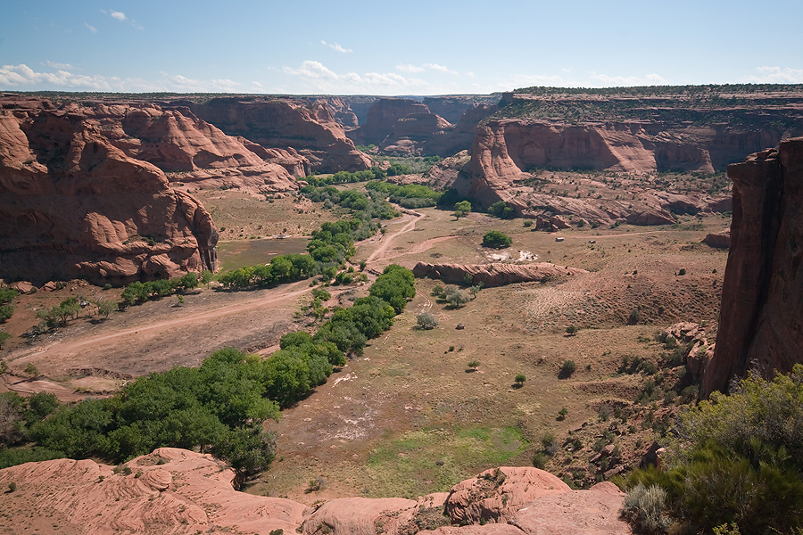

      Junction

      Tseyi

      I then grabbed some lunch from Subway - the great oasis in a sea of sugar, fat and salt that is most take away offerings - in Chinle and headed for the 3 hour drive to the Grand Canyon. Needless to say, the weather turned nasty:

      Storm viewed from Hwy 264

      In fact, there were reports of four tornadoes in northern Arizona today - unheard of according to the locals. I didn't see one but there were a few severe storms around.

      I reached the Grand Canyon National Park in time to get some photographs of the late afternoon and sunset. First impression - it is a bloody big hole in the ground! See separate post for photographs.

      PS. I did manage to find out how the name Chinle is pronounced - in English chin-lee, in Navajo, ch'en'le - much nicer but almost impossible for those of us who suffer from the English need to fill all the space in a word with sound. Navajo is a beautiful sounding language - softly spoken with subtle pauses (noted as apostrophes above) in many words.